CLEARWATER WEST IMPACT CRATER
by: Charles O’Dale
- Type: Peak ring
- Age (ma): 290 ± 20a – PERMIAN
- Diameter: 32 km
- Location: Quebec, Canada. N 56° 13′ W 74° 30′
- Shock Metamorphism: Maskelyniteb, PDF in quartz grains, shatter cones and spheroids derived by liquefaction of strongly shocked rock fragments.
a K-Ar dating of the melt rocks. No meteorite component has been detected in the Clearwater West melt rocks (Reimold et al 1981).
b Maskelynite: A type of naturally occurring glass having the composition of plagioclase series feldspar, created by the vitrification of plagioclase by shock melting in meteorites and meteorite impacts. (Dence et al 1967)
2024 UPDATE
Personal correspondence with Professor Sean Gulick of the Institute for Geophysics, UTexas, regarding peak ring craters on our planet:
Clearwater West is just over the size limit where it could have a peak ring but given its Permian age and erosion the structure is not fully preserved. The ring like feature thus could be a peak ring or could be like Ries Crater where its an upturned edge of a terrace zone/slump blocks. Popugai may also have one but again not confirmed. Sudbury and Vredefort certainly had them but these are highly eroded (5 km and 10 km respectively). So currently Chcixulub is only confirmed, intact peak ring on Earth.
![]()
The magnetization of rocks.
The magnetic field of the Earth can be “captured” by certain types of rocks, and this magnetic signature can be used to study the Earth’s magnetic field throughout history. The magnetic poles of the Earth are not fixed, and pole reversals have occurred many times in the past.

The rocks from the West Lake show that they were formed during a “superchron,” which is an unusually extended period of time where no reversals occurred. This superchron, known as the Permo-Carboniferous Reversed Superchron, lasted from 316 to 265 million years ago, which agrees with the age found by the argon dating.
The rocks from the East Lake tell a different story. They have a number of different magnetic polarizations, which indicate viscous remnant magnetization. This is magnetization that is acquired slowly over a long period of time. The more complex magnetic history points to the rocks being much older than the West Lake, as they have had more time to be altered.
R. P. A. Wilks, and G. R. Osinski,IMPACT MELT VEINS IN THE CENTRAL UPLIFT OF THE WEST CLEARWATER LAKE IMPACT STRUCTURE, NORTHERN QUEBEC, CANADA.Lunar and Planetary Science Conference 2015

New Ar-Ar Dating of the East and West Clearwater Lake Impact Structures, Québec, Canada – Evidence for Two Separate Impact Events; Martin Schmieder , Winfried H. Schwarz , Mario Trieloff , Eric Tohver , Elmar Buchner , Jens Hopp , Gordon Richard Osinski and Richard A F Grieve
![]()
Abstract: For 50 years, the two Clearwater Lake impact structures in Québec have been considered as a typical crater doublet formed by the impact of a binary asteroid. New Ar/ Ar dating of melt rocks from the ≥36 km West Clearwater Lake (WCL) impact structure yielded two Early Permian plateau ages with a weighted mean age of 286.2 ± 2.2 (2.6) Ma (2σ; MSWD = 0.33; P = 0.57). Ar/ Ar results for two chloritized melt rocks from the ~26 km East Clearwater Lake (ECL) impact structure produced age spectra suggestive of extraneous argon. The age spectra corrected for the trapped argon component and inverse isochron plots consistently yielded ages around ~460–470 Ma for ECL, reproducing the Ar/ Ar results by Bottomley et al. (1990) and contradicting an earlier Rb–Sr age of 287 ± 26 Ma. The Ar-Ar dates obtained from four different melt samples across the melt sheet favor an Ordovician age for the ECL impact and impact-induced hydrothermal overprint. WCL and ECL, moreover, show different natural remanent magnetizations indicating separate geologic histories. Whereas WCL has no resolvable geochemical impactor traces, the ECL melt rocks carry a strong (possibly L-) chondritic impactor signature. The WCL impact affected a thin layer of Ordovician target carbonates; such rocks are absent in the ECL impact breccia, which is overlain by >100 m of post-impact sediments. Biostratigraphic dating of the fossil-poor post-impact deposits at ECL is currently underway. In the light of the new Ar/ Ar dates and in combination with the paleomagnetic and geochemical findings, the close spatial arrangement of WCL and ECL is probably pure coincidence. The two impact structures seem to represent a ‘false doublet’ struck by impacts ~180 million years apart. ECL possibly represents one of several impact structures.
Martin Schmieder, Winfried H. Schwarz, Mario Trieloff, Eric Tohver, Elmar Buchner, Jens Hopp and Gordon R. Osinski
Abstract – The two Clearwater Lake impact structures (Québec, Canada) are generally interpreted as a crater doublet formed by the impact of a binary asteroid. Here, arguments are presented that raise important questions about the proposed double impact scenario. New 40 Ar/39 Ar dating of two virtually fresh impact melt rock samples from the >36 km West Clearwater Lake impact structure yielded two statistically robust Early Permian plateau ages with a weighted mean of 286.2 ± 2.2 (2.6) Ma ( MSWD = 0.33; P = 0.57). In contrast, 40 Ar/39Ar results for two chloritized melt rocks from the ~26 km East Clearwater Lake impact structure produced disturbed age spectra suggestive of a distinct extraneous argon component. Although individually weakly robust, age spectra corrected for the trapped argon component and inverse isochron plots for the East Clearwater melt rocks consistently yielded apparent ages around ~460–470 Ma. No Permian signal was found in either of these melt aliquots. Our new 40Ar/39Ar results reproduce earlier 40 Ar/39 Ar plateau ages (~283 Ma and ~465 Ma, respectively) for the two impact structures by Bottomley et al. (1990) and are in conflict with a previous, statistically non-robust Rb-Sr age of 287 [293] ± 26 Ma for East Clearwater. The combined cluster of apparent ages of ~460–470 Ma, derived from four different samples across the impact melt sheet, is very unlikely to represent a ‘false age effect’ due to the incorporation of extraneous argon into the melt; instead, it strongly favors a Middle Ordovician age for the East Clearwater impact and impact-generated hydrothermal chloritization. Moreover, the Clearwater impact structures are characterized by different natural remanent magnetizations testifying to separate geologic histories, an effect unexpected in the case of a Permian double impact. Whereas the West Clearwater impact affected Ordovician carbonates incorporated into the impact breccia, drill core reports from the 1960s concluded that clasts of Ordovician sedimentary rocks are seemingly absent in the impact breccia lens of the East Clearwater Lake impact structure, which is overlain by >100 m of post-impact sandstones, shales and carbonates. No resolvable impactor contamination has so far been detected in the West Clearwater impact melt rocks, whereas East Clearwater carries a distinct ordinary (possibly L-) chondritic impactor signature in its melt rocks. East Clearwater Lake might thus represent one among a long list of Ordovician impact structures in North America and northern Europe that were presumably generated in response to the L-chondrite asteroid breakup event ~470 Ma ago. Paleogeographic reconstructions show that the Ordovician East Clearwater impact probably occurred in a near-coastal to shallow marine setting, while the Permian West Clearwater impact hit continental Pangaea. Along with the new 40 Ar/39 Ar data, the paleomagnetic, sedimentologic, and paleogeographic findings suggest that the close spatial arrangement of the two Clearwater lakes is probably pure coincidence. The two impact structures seem to represent a ‘false doublet’ struck by impacts separated by ~180 million years in time. The new results for the Clearwater Lake impact structures have major implications for the reliable identification of doublet impact craters and the rate of binary asteroid impacts on Earth and on other planetary bodies in the inner Solar System.
M. R. Dence, W. von Engelhardt, A. G. Plant, L. S. Walter
Abstract – Glass from the West Clearwater Lake hypervelocity impact crater contains numerous spheroids, 10 to 500 μm across, which appear to have formed at high temperatures as fluids immiscible in the enclosing melt. The spheroids are distinguished from small, normal, largely void gas vesicles, which are also present, by being completely filled in all cases; by having fillings which vary in composition from spheroid to spheroid, even between spheroids in close association; and by indications that the present fillings are representative of the contents present before the matrix melt chilled. Most of the spheroids are classified petrographically into three types. Type I, the most numerous, includes all spheroids>100 μm and are filled with uncommon pale brown to yellow montmorillonites with an unusual structure intermediate between dioctahedral montmorillonite and saponite. Type II, brown and green, are filled with Fe-rich montmorillonites, while Type III are aluminia-rich montmorillonites crystallized into mica-like sheaves. Rare, small spheroids are filled with calcite or silica. In a few cases one spheroid encloses another of similar or different type. Electron microprobe analyses indicate that with few exceptions Types I and III spheroids belong to a Mg series of montmorillonites in which the main chemical variation is the substitution of Mg for Al. A second Fe-K series includes Type II and a few Type I spheroids and shows substitution of Fe by Al, relatively high K2O and, in the alumina-rich members, low SiO2. The close association of spheroids with deformed, embayed lechatelierite inclusions indicates that they formed while the latter were liquid, i.e. at temperatures above 1700°C, as rapidly moving impact melt engulfed highly shocked inclusions of quartz-bearing country rock. The preservation of spheroids in the West Clearwater Lake glass is attributed mainly to the position of the glass masses within the breccias lining the crater floor. It is considered that the glass in this location did not achieve free flight but, as part of a large mass, cooled relatively slowly through the high temperature regime in which the spheroids were generated, and then, when detached, chilled rapidly to preserve a record of this transient stage in their history.
General Area: The Clearwater Lakes lie within the Canadian Shield, close to the treeline. Their circular form contrasts sharply with the linear and irregular lakes in this area of generally low relief. The area has been glaciated. The target rocks are crystalline.Specific Features: Twin craters, formed simultaneously by the impact of an asteroidal pair. The eastern,smaller structure has a submerged central peak. The western, larger structure contains a prominent ring of islands, that are 6-10 km in diameter. This ring is capped by impact melt rocks. A fracture halo extending out 20-30 km from the structures is visible at low sun angles. The lakes are named after their exceedingly clear water.
An article by Beals et al in the 1964 Journal of the RASC article (below) proposed that the Clearwater Lakes double structure may be the result of a cosmic impact. This report was published before any geological studies were performed at the site in order to find impact features.
The Clearwater Lake Crater pair is situated in crystalline bedrocks of the Canadian Shield. Data is consistent with the eastern and western structures being the result of simultaneous impacts. The size and separation of the two structures rule out the impact of disrupted single body by either atmospheric breakup or fragmentation within the Roche Limit, suggesting that the impacting bodies were a binary pair (Melosh et al, 1991). The Clearwater Lakes East and West* craters are a classic example of the impact of a contact binary asteroid creating this twin crater phenomenon, very rarely recognized on Earth (Grieve 2006).* [2017 – SEPARATE IMPACTS – see papers above]. The larger Clearwater Lake West Crater (in the NASA/LPI image) shows a prominent ring of islands that has a diameter of about 10 kilometres (6 miles). The islands constitute a central uplifted area and are covered with units of breccias and impact melt. The shore line of the crater contains numerous small islands. The land rises from lake level to a poorly defined ind interrupted rim 5-10 km from the shore. Bathymetry indicates an annular trough between and the ring of islands, with depths of ~50m. The crater is classified generally as a complex meteorite crater with a peak-ring form (Grieve 2006).
The ring of islands reflects the eroded centrally uplifted rocks of the original crater and contains impact melt. Impact related lithologies are known only from the island ring and from drill core. Poorly formed shatter cones occur on the island ring but their orientations have not been studied in detail. The metagabbro of the central islands contains maskelynite and planar deformation features in quartz (Grieve 2006).
During an expedition to the structures in the winters of 1962-63 and 1963-64, drilling and gravity surveys were performed. The results were interpreted in favour of the structures being of impact origin (Dence, 1964; Dence et al, 1965):
- The melt bearing units are approximately 100 meters thick;
- Below the melt is a 10 meter thick breccia layer;
- A 300 meter thick layer of fractured basement rocks complete the base of the crater, and;
- Some of the larger fractures in the basement show displacement and contain pseudotachylite.
Aerial Exploration
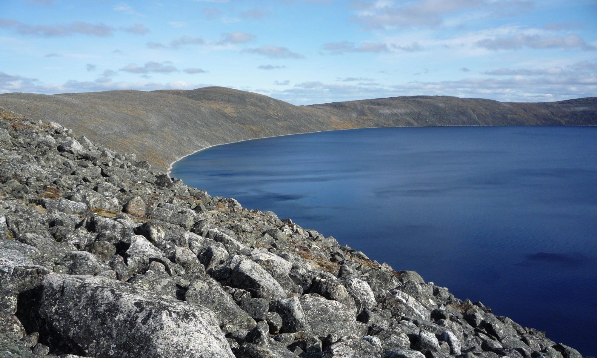
We approached these twin craters from the northeast under a 1500’ cloud layer, the weather patterns over each crater were completely different. Clearwater East had a couple of rain systems covering the south shore of the crater while Clearwater West was almost completely clear. Fuel constraints prevented a longer stay over the area to wait out the weather. After exploring as long as fuel would allow we departed to the west.In the following images note the vegetation. We are just south of the “tree line”, which to us means that if we had to make a forced landing, we could now find something to burn in order to make an emergency fire!
Ile Kamiskutanikaw is the north eastern-most island section of the crater ring. From this position, in the western ring islands are visible to the right. The southern crater ring is prominent in the near background with the southern crater rim visible in the far background. From here we orbited the ring islands in a counter clockwise direction.
We continued flying west along the north coast of this island. The geology on these islands illustrates the impact melt.
Scanning right (west) from the previous illustration, still north of Ile Lepage, is the western-most point of the northern island. Looking southwest from here are Iles Wiskichanikw, the series of small islands that make up the western-most ring feature. We crossed the most northern island at its western-most point.
Looking east from the western-most point of Ile Lapage the common crater rim between Clearwater East and West is just visible at the extreme left background. The circular form of the ring islands is obvious even from this low altitude. We continued south over Iles Wiskichanikw to Ile Atkinson, the southern-most island in the crater ring.
After flying over the small western islands we explored the southern-most island, Ile Atkinson. Looking northwest from the western-most point of Ile Atkinson, Iles Wiskichanikw are visible in the left foreground with the northwest crater rim in the far background. Ile Kamiskutanikaw is just visible in the right background. These images give an excellent perspective of the size of this crater.
We travelled east exploring along the south coast of Ile Atkinson. This image is taken looking northeast from the southern point of Ile Atkinson. The eastern point of Ile Atkinson is visible in the foreground, the northern crater rim of Clearwater West is just visible at the upper left, Ile Kamiskutanikaw is in the mid background and the common crater rim between Clearwater East and West is visible at the upper right of the image.With the crystal clear water and pristine islands, I couldn’t help thinking that this is the perfect place for a cottage. The very short summers, cold winters and extreme isolation puts it in a bit of perspective though!To fully explore these craters unfortunately would take more fuel than my airplane could carry. So, after exploring as long as fuel would allow we departed to the west for the village of Umiujaq. There we would top up our fuel from the containers we carried and continue on south and home.
Side Notes
1. PEAK RING CRATERS
GOSSES BLUFF AUSTRALIA


Double-ring craters do occur as well on Earth’s Moon, but they are much more common on Mercury, and smaller in size. This is a function of Mercury’s greater gravity. The immediate vicinity of the impact crater is pockmarked by locally derived impact ejecta associated with radial secondary impact crater chains. The impact and pockmarking is clearly younger than the smooth volcanic plains to the left in this image. Because the major phase of impact cratering in the Solar System is associated with the Great Bombardment that ended at 3.8 billion years ago, the presence of smooth lavas that drown older craters – but which are also heavily impacted by younger ones – tells us that the lava plains are probably about 3.8 billion years old as well. This highlights yet another difference with Earth’s Moon where the lavas that filled up the giant Impact Basins are 100’s of millions of years younger than the end of the Great Bombardment. (from: Messenger at Mercury (Feb 2008) by Simon Hanmer.)
2. “TWIN” IMPACT CRATERS

3. LUNAR ANALOG

There are a pair of craters, Ritter and Sabine, visible on the moon in the south west corner of Mare Tranquillitatis at 2°N latitude 19°E (lunar coordinates for Ritter Crater). Observing these craters will give you an excellent perspective of the physical size of the Clearwater Craters as these twin craters on the moon are “almost” the exact dimension and orientation of the Clearwater Craters. In other words, an observer on the moon would see the twin Clearwater Impact Structures almost exactly as we see the Ritter/Sabine Craters on the moon from our planet (courtesy NASA)
4. AREA GEOLOGY
I just wanted to share this with you.
References
[see – METEORITE]
Beals, C. S., Ferguson, G. M., & Landau, A., [Scientists Report II.] A Search for Analogies Between Lunar and Terrestrial Topography on Photographs of the Canadian Shield, Part II,Journal of the Royal Astronomical Society of Canada, Vol. 50, p.257-258
Brent Dalrymple, Radiometric Dating Does Work! Reports of the National Center for Science Education
R. Terik Daly , Peter H. Schultz, John C. Lassiter, Staci W. Loewy, Lucy M. Thompson, John G. Spray; Contrasting meteoritic signatures within the Clearwater East and Clearwater West impact structures: The view from osmium isotopes Elsevier 15 June 2018
Dence, M.R., Bunch T.E. Cohen A.J. NATURAL TERRESTRIAL MASKELYNITE, THE AMERICAN MINERALOGIST 1967

Dr. Michael R. Dence and yours truly at a 2012 Sigma Xi Companions in Research meeting, Ottawa. Dr. Dence was prime on impact crater research within the Canadian Shield, 1961-81. He was one of the few indiviuals responsible for transforming terrestrial impact crater research into a respectable and scientific discipline of planetary science.
Dence, M. R., A comparative structural and petrographic study of probable Canadian meteorite craters. Meteoritics, v. 2, pp. 249-270. 1964.
Dence, M. R., Innes, M.J.S. and Beals,C.S., On the probable meteorite origin of the Clearwater Lakes, Quebec. Journal of the Royal Astronomical Society of Canada, v. 59, pp. 13-22. 1965.
Doyle, A., Surprise! Canadian Double Crater Formed by 2 Separate Impact Events.Astrobiology Magazine, March 13, 2015 07:00am ET
French, B. M.,The importance of being cratered:The new role of meteorite impact as a normal geological process. Meteoritics & Planetary Science 39, Nr 2, 169–197. 2004.
Grieve, R.A.F. et al, 40 Argon/39 Argon Dating of Impact Craters Proceedings of the 20th Lunar and Planetary Science Conference 1990
Grieve, R.A.F., Impact Structures in Canada. Geological Association of Canada, 2006.Hanmer, S. Messenger at Mercury (Feb 2008). RASC Ottawa Centre.
R. P. A. Wilks, and G. R. Osinski,IMPACT MELT VEINS IN THE CENTRAL UPLIFT OF THE WEST CLEARWATER LAKE IMPACT STRUCTURE, NORTHERN QUEBEC, CANADA.Lunar and Planetary Science Conference 2015
Reimold, W. U., Grieve, R.A.F. and Palme,H., Rb-Sr dating of the impact melt from East Clearwater, Quebec. Contributions to Mineralogy and Petrology, v. 76, pp. 73-76. 1981.