2001 CRATER TOUR QUEBEC CANADA
by: Charles O’Dale and Terry Peters

Video of my Pingualuit overflight in GOZooM:
- LaMoinerie Crater @ 0:01
- Kuujjuaq Village @ 2:00
- Northern Terrain @4:00
- Pingualuit Crater @ 6:30
- Landing Salluit @ 16:30
Chuck:
An old dream of mine was to visit the Pingualuit (aka Chubb) crater in northern Quebec Canada. The dream started when I saw Dr. Meen describe his ground exploration of the crater. I was still in public school but I vowed to someday get to see that crater.
Years later I proposed this trip to a friend of mine, Terry Peters a flight instructor and like me, retired from the military. His answer “OK, lets go!”
Here we describe our experiences;
Sunday 26 Aug
CYOW (Ottawa) to CYRC (Chicoutimi)
Air Time 2.6
GPS Distance: Ottawa – Mirabel – Quebec – Charlevois – Chicoutimi = 356nm
Average Speed 136.9 Kts
Terry:
Left Ottawa at 7:50am and headed beyond Quebec City to see the Charlevois crater, which is on the edge (north shore) of the St. Laurence River. My first informed visit to a crater. We circled overhead for pictures and a great view of the half bowl shape quite distinctive from the air. About 54 miles across and 357 million years old (±15). Carried on to Chicoutimi where we landed for gas and lunch.
Chuck:
Terry and I agreed to alternate flying each of the legs of the fight and I would do the landings and takeoffs. This to allow the off duty guy to absorb more of the scenery. The first leg was mine to fly; it was almost IFR (but we could see the ground) with a good tail wind. It started to clear by Quebec City where we got some good shots of the largest cantilever bridge, the Plains of Abraham and Montmorency Falls (the scene of some pretty bloody fighting during Gen. Wolf’s campaign). We followed the north shore of the St. Lawrence River until the Charlevoix Crater.

The size of the Charlevoix Crater impresses me every time I see it. We cannot get the whole crater in one picture, and this is from 5,500 feet. On the west rim of the crater, just where it meets the St. Lawrence there is an island where apparently there is a good resort and it has a little strip to land on. On the north rim there is a bicycle path with camping sites. It takes a few days to do the trail; there is an agency that supplies cabins along the trail for the cyclists.
From Charlevois it was northeast to Chicoutimi for breakfast and gas – the 100ll kind! (Good scenery at Chicoutimi)
CYRC (Chicoutimi) to CYKL (Schefferville)
Air Time 3.5
GPS Distance: Chicoutimi – Manicouagan – Schefferville = 438 nm
Average Speed 125.1 Kts
Terry:
Beyond Chicoutimi is a huge crater – Manicouagan. It’s 100 km across! – one of the largest impact craters still preserved on the surface of the earth. 212 million years old. Unfortunately shortly after departing Chicoutimi we ran into low clouds that were uncomfortably close to the hilly ground and eventually had to climb. We did manage to catch glimpses of the southern and northern parts of the crater through breaks in the cloud but didn’t get a complete view of the whole thing.

We were in cloud for half of the 3:35 hr trip to Schefferville, so not much sightseeing on this leg. Schefferville provided the most exciting arrival of the trip. A howling crosswind got the adrenaline at maximum, but the landing was successful (no parts damaged or lost). The refuelling guy wanted $75 as a call-out charge because it was Sunday. Since it was getting on for 4:00 PM we decided to call it a day and put the fee towards accommodation and refuel in the morning. A friendly local drove us to a nice lodge where small rooms were available (only room for two single beds – showers and toilets down the hall). Very expensive (everything up north is) but included a large dinner of caribou meat and breakfast. The friendly local owned the lodge and was also an undertaker, ambulance driver, grocery store owner and local entrepreneur.

Chuck:
This leg was Terry’s to fly. While we were leaving the zone the tower gave us some great advice. It was very scuddy where we were headed and they advised up to follow the hydro lines through the hills to the north. Apparently, that’s what the bush pilots do. That was OK until the hydro lines disappeared in the scud. Terry’s IFR rating saved the day and we punched through into uncontrolled airspace. Unfortunately, we were skunked at the Manicouagan Crater. Through the scud all we saw was a bit of the south and a bit of the north rims. Past Manicouagan the scud lightened a bit enabling us to get under without a risk of hitting anything.
At 1500 AGL it was great. We enjoyed the ride so much we did this for the rest of the trip through northern Quebec. I kept the MP at the top of the green and ran 2100 RPM. That gave us 120 Knots at ~9.3 GPH. The scenery was spectacular and it just got better.
At Schefferville we had hairy-ist crosswind landing of my life! The wind was from the left at 18G30 at 89 degrees across the runway. My right foot was on the floor with almost full left aileron. I kept on the glide path with throttle. I aborted the first attempt after I was on the ground and could not get directional control. The second approach was longer and I planted the wheels real good but OZM still jerked to the right, I was too slow on left rudder! Terry saved it when he jammed on the left rudder!! He said his instructor and tail dragger instincts came into play. I didn’t mind a bit!!

In conversation with people at the airport after we taxied in (they were probably there to witness the crash), they mentioned that the bush pilots stopped flying at 10:00 that morning (then these two Yahoos from Ottawa come in and do an x-wind landing!!). They also mentioned that some airplanes land on the taxiway in these conditions, which was exactly into the wind. I was thinking about doing that if I aborted the second approach.
I had brought a jar of Scotch to toast our fly-over of the Pingualuit (Chubb) crater, but this occasion justified cracking and emptying the jar. Afterwards we did a ground tour of Schefferville (with a bit of a “glow” on). It’s a typical mining ghost town with lots of boarded up or abandoned buildings. The mine closed in 1985 with the drop in demand of iron ore. It’s a good thing we didn’t stay at the town hotel. I don’t think we would have gotten any sleep with the noise coming from the full bar.
I collected my souvenir rock.
The lodge we stayed at had a policy of “leave your shoes at the door”; first time I’ve experienced that at a hotel. After our excellent caribou supper, the owner pulled out an old map (6 X 6 foot) of Quebec. It showed the Manicouagan Crater before the reservoir was constructed. I would love to have had the chance to rockhound in that dry crater!

Monday 27 Aug
CYKL (Schefferville) to CYVP (Kuujjuaq)
Air Time 3.3
GPS Distance: Schefferville – Mistastin – La Moinerie – Kuujjuaq 381nm
Average Speed 115.5
Terry:
Monday morning it was east over Labrador to two more craters, Mistastin and La Moinerie. Mistastin is 28km is diameter and 38 million years old. Moinerie is relatively small at 8km across – 400 ±50 million years. Then it was north to Kuujjuaq (formerly Fort Chimo). The flight took 3½ hours including circling for picture taking. The chart showed us crossing “the limit of the tree line” on this leg. The ground was nothing but rock, partially covered with lichen. There were thousands of small lakes. The small town of Kuujjuaq up river a short way from Ungava Bay consists mainly of tidy square two-story houses. One fairly modern looking house overlooked the river, right on the approach to one runway. The runway we used was gravel – well kept and hard packed (we saw a large roller being used on it), with a considerable up-slope (61 feet at one end, 129 feet at the other). Another runway that was asphalt was undergoing repairs. Jets using the gravel runways common in the north, have a probe under each engine pod that blasts air down to deflect any gravel away from the intake.
Some workers gave us a lift to the small hotel at the edge of town, about 2km from the airport, for lunch. We walked back and visited the Flight Service Station for weather info etc. for our next leg to the Pingualuit crater (aka Chubb or New Quebec crater) and on to Salluit (formerly Saglouc), on the north coast of Quebec overlooking Hudson Straight.


Chuck:
We got payback with the winds, the crosswind we fought yesterday was a good tailwind for this morning. The territory just got more interesting as we penetrated Quebec. There were well-worn paths everywhere we looked. We only could surmise that they were caribou tracks. Mistastin Crater was the most dynamic to see, of the two we saw on this leg. Its “original” crater form was still preserved to some extent. As we turned north west the tailwind now became a 45 degree wind forward from the left. The ground speed went from 130 +k to < 100 k. La Moinerie crater appeared in front of us from over 30 miles away. We circled and documented the impact site for the album.
Most of the craters we will be seeing are holes in the bedrock, the glaciers having eroded and transported away all evidence of the impact crater rim and ejecta. There is a lot of eskers and glacial till evidence. Great geology!!!! The river valleys were miniature Grand Canyons. Pictures do not give them justice. Passing the tree line I thought that if we go down here there will not be much to make a fire with!!

I didn’t pay attention to or didn’t ask about any advisories on Kuujjuaq. We found out that the paved runway was closed when we arrived, so we had another crosswind landing, this time on gravel. It was a rather tame 10-15 knot crosswind and I aced it!! The ramp at Kuujjuaq was pretty busy with jets and turbos going hither and yon. The tower personnel were very friendly giving us lots of advisories for our next leg.
Monday 27 Aug
CYVP (Kuujjuaq) to CYZG (Salluit)
Air Time 3.5
GPS Distance: Kuujjuaq – Pingualuit – Salluit = 410nm
Average Speed 117.1 Kts
Terry:
We were off the ground at Kuujjuaq around 3PM with the Pingualuit crater, a major attraction (for us!) about 250nm (roughly two hours) away. The visibility was unlimited, except that there was an overcast at around 3000 feet, with only occasional breaks for sunshine to show through. The barrenness of the territory was cause for some reflection. Certainly not a place to be stranded. Caribou tracks were visible all over the place, but not a caribou to be seen. This was about the only disappointment of the whole trip. We never did see a caribou herd.

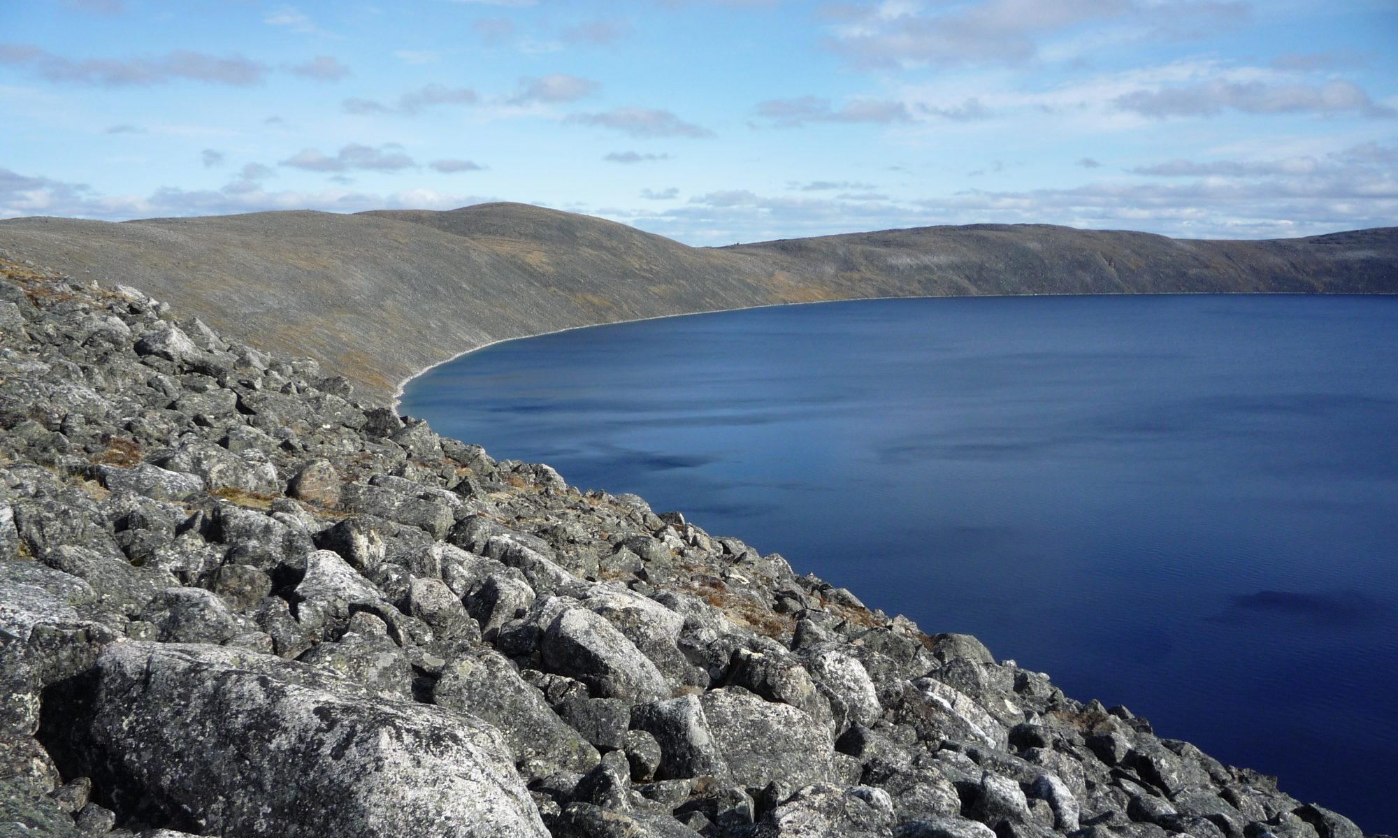
From at least 30 miles we could see the rim of the crater on the horizon. The crater itself was a most impressive sight. It was first recognized as an impact structure in 1950. It’s relatively young – only 1.4 million years and almost perfectly circular, 3.4km in diameter with a raised rim up to 163 meters above the lake surface in the central flooded depression. The lake is 252 meters deep. We must have spent nearly 45 minutes circling it to take photos and video before leaving for Salluit, about 40 min. away. It would have been nice to have landed and visited it on foot but this was a pretty unfriendly and desolate place. Perhaps another time on floats or with large tundra tires!!


Chuck:
It was Terry’s turn to fly, which gave me maximum eye time at Chubb Crater (thanks Terry). While we were taxiing out from Kuujjuaq, I had to exit the taxiway to let a turbo go by with no thank you from them or anything. Ivory towers EH? Oh well. The FSS did not give us advisories that a turbo was on its way in, we could not see it from the ramp when we started taxiing.

I cannot add to Terry’s description of the Chubb crater, he said it all. From our altitude, we could not see the water in the crater until we were less than three miles from the rim, it is that deep! The water in the crater was a very sharp blue colour. The size of the crater is not obvious from the air, apparently if you are standing on the rim and throw a rock as hard as you can into the crater, you will only get about half way to the water.

It was a lifelong dream of mine to see that crater live! I just stared out the window, letting the video run and taking lots of pictures. As we went higher to get a better view, we passed the freezing level (about 2500’) and the windows frosted over! One day I will walk that crater rim!!

After Chubb, we did a low and over past an abandoned prospector site. From a distance it looked intact, but a closer look showed the wind damage on the huts. The strip by the camp was usable if we had to.
Terry:
Salluit (Inuit word for “skinny people”) is situated on a bay surrounded by hills and overlooking Hudson Straight. It’s hard for me to imagine living in such isolation, but the Inuit have lived here for centuries. The airport is relatively new (less than 15 years) so until very recently access was via small floatplanes in the summer or by larger ski-equipped ones in the winter. Ships still bring in supplies during the relatively short ice-free period in the summer. We walked down into the settlement (2 miles or so from the airport – elevation 740ft) on a densely packed gravel road, designed to hold up against the permafrost. The houses are all square, two stories high, shipped in by boat (there are certainly no building materials in this part of the world). They’re placed on shafts that reach below the permafrost. The walls of the second stories are all painted bright blue, green or red, with the ground floor generally white. And all the gravel streets are laid out in neat rows. Would have loved to take pictures of children playing with husky puppies and mothers in Inuit coats carrying babies on their backs, but that would have been rude. It was obvious we were visitors of course and most gave us friendly waves and smiles. Some just ignored us! Several small boats with outboard engines were pulled up on the shore. The economy is based on seal, beluga whale and walrus hunting. A mine 50km from Salluit, at Deception Bay, is a significant player in the local economy. There were three or four pickups, used to carry supplies between the village and the airport. We saw a few 4-wheel dune buggies and one or two mopeds and small motorcycles. About 1030 people live in the village. Some houses are being built a mile or so inland since there is no more room to expand the present housing area.

The uphill walk back to the airport gave us more than enough exercise at the end of a long day. Even though it was about 2°C, (and this is August 27th!) we had to take our parkas off! Accommodation in these isolated communities is scarce and very expensive, so we had decided earlier that we would tent. We put it up on the crest of a hill just below where the aircraft was parked on the ramp. The wind snapped away at the tent all night. It rained most of the time but not enough to get rid of the snow patches nearby. In the morning we were fogged in. We used the time to fold up the tent and refuel. Fuel is available at isolated communities but you have to buy a whole 45 gal. drum for $500. Knowing this, we carried an extra 20 gals. with us in 5 gal. containers.
Chuck:
At Salluit, we made a detour to put the wheels over the Hudson Strait. The scenery there was spectacular, a beautiful fjord with a small village in a little nook of the cliff.


Our reception at the terminal was less than spectacular!! The agent working there totally ignored us. I would have been curious about a small airplane at such an isolated strip. Strange!! The temperature at the airport was just on the freezing point so I had my heavy parka on for the walk into town, big mistake!!

It was a three-mile down hill walk and we went right to the water to “touch” the salt water. I carried my parka for the walk back, the airport elevation is 742 feet. Terry is in pretty good shape!!

I had my military –30C sleeping bag for the night (a double bagger). So, I thought if Terry and I each used a half, it should keep us plenty warm, again big mistake. I never got cosy warm at any time during the night. It was a dark and stormy night!! Except for one time when the wind stopped completely, it was totally calm, eerie!! We woke up to total fog!!
Tuesday 28 Aug
CYZG (Salluit) to CYVP (Kuujjuaq)
Air Time 3.0
GPS Distance: Salluit – Lac Couture – Kuujjuaq = 382nm
Average Speed 127.3 Kts
Terry:
Two visiting technicians (Telesat and Quebec Hydro) gave us a ride into town and back to pick up some food at the co-op and by about 2PM the visibility and ceiling had improved enough to get us off the ground.
Chuck:
As we waited in the terminal for the weather to clear, an Air Inuit flight was waiting to go as well. This gave us a chance to talk to various people from the village. The Inuit men seemed to talk OK in English but did not seem to comprehend as they asked a lot of repeat questions. I tried to get a few “old stories” from a few of the men. Unfortunately, the “old ways” seem to have been completely forgotten. All the tales were of experiences with white men and their ways, no one seemed to have a memory of their nomadic lifestyle. The guys from Telesat and Quebec Hydro were very friendly and helpful. We scrounged a ride into the grocery store for a jug of milk and some cheese. I had a can of cold beans for lunch. Kraft dinner was $1.74/box!!!!

Terry:
Weather reports showed clearing to the south. We were in cloud for nearly an hour. Trying to climb on top didn’t work. We climbed to 10,000ft and were still in cloud so let down and broke out at about 2000ft – and with good visibility to proceed to the next crater, Lac Couture, 8km across and 430million years old (±20) before heading back to Kuujjuaq for the night.

Chuck:
Again, Terry’s IFR rating saved the day allowing us to depart. I made sure the stick was way back to keep the prop out of the loose gravel on the runway. Our climb rate was enough to clear the invisible hills at the end of the runway. We climbed to 10000’ and still didn’t break our. Finally I could see the ground in places, so down we went under the stuff. About 30 miles south of Salluit we were scud running VFR.

Lac Couture is a big crater!! The rim is completely eroded away, all that is left is the shape of the impact basin in the bed rock. We contacted an Air Inuit A/C on 126.7 and asked them to relay a position report for us. It’s our CASARA upbringing, position reports as many as possible. Unfortunately, 126.7 is VERY QUIET up north. Again the scenery up there was spectacular.

The landing at Kuujjuaq was interesting! As we arrived we were advised that a turbo was doing circuits and the turbo was not advising his intensions on the radio. I gave him a wide berth and let him land way in front of us. As I turned final the sun was directly in my eyes and then we realized that the turbo did a full stop on that circuit. So I slowed right down, hanging on the prop until he finally decided to go. Add a crosswind to an uphill runway to slow flight into the sun and things get interesting. The turbo finally moved and we got down, actually the landing was pretty good!
We had planned to do a trip to the mountains of Labrador that afternoon, but unfortunately our late departure from Salluit put the kybosh on that. Oh well, another trip perhaps!
We asked the tower to advise the fuel man that we were there. The tower advised us that the call out charge was in effect, we missed the time by 45 minutes. When we pulled up to the parking area, the gas attendant was there filling a turbo so I asked him if I would have to pay the callout fee if I filled up now. The answer….. YES $75 please. No thanks, I waited until morning, unfortunately delaying our departure the next day.
In the tower, we phoned the hotel to make sure there was a room available, there was, so we bit the bullet and paid the exorbitant fee for a night at the hotel. We had a pleasant walk into town and stopped for pictures at the Kuujjuaq icon (stone statue depicting the Inuit constructions that herd the caribou into the hunters trap). I had one of my longest hot showers, finally getting warm from last night!!
I made sure I got my rock sample.
Wednesday 29 Aug
CYVP (Kuujjuaq) to CYMU (Umiujaq)
Air Time 3.6
GPS Distance Kuujjuaq – Clearwater East & West – Umiujaq = 345nm
Average Speed 95.8 Kts
Terry:
The last day and it was a long one! The final craters on our route were the double ones called Clearwater Lake (east and west), about two hours flying time west of Kuujjuaq. These were formed by an impact from twin asteroids (recent documentation states that the craters are the result of two individual events separated by millions of years) . Another very impressive sight, particularly if you realize what you’re looking at.
This part of northern Quebec is just miles and miles of treeless rock and thousands of lakes and countless caribou tracts. There were also quite a few prominent eskers. I took lots of pictures but they just don’t capture the vast desolation. The engine never missed a beat but one does reflect from time to time! We continued on to Umiujaq, another isolated Inuit community, on the east shore of Hudson’s Bay, to add fuel from our containers ……
Chuck:
The revolution counter was at 2266.6 (the antichrist address or is it 999?), our engine start was 13:13Z and it was my turn to fly. I repeated my Sceptic’s creed “It’s bad luck to be superstitious” and carried on. The wind was right on the nose for the whole trip to Hudson’s Bay, we were making about 90 k ground speed. On the plus side, it gave us longer to look at the great scenery. Our track followed the River aux Melezes, again spectacular!
We documented a circular lake at 56 35 N 72 36 W that looks like an impact scar in the bedrock.

By the time we approached the twin Clear Lake Crater we were dodging rain clouds, but the larger crater to the west was clear for our visit. It is really big!!!
Who ever was standing there 290 million years ago had a bad day! It is one of the few twin craters with a double rim feature on earth, which makes it particularily interesting. We didn’t completely circle the features as we would have been pushing our gas supply, it’s that big! We circled the inner rim of the west crater. I would love to explore those islands. The lake is very clear, at great place for a cottage. After the craters it was direct to Umiujaq. The cliffs and valleys approaching the village were spectacular!! (sorry to keep using that word but it’s the only way I can describe what I was seeing).
We had a connoisseur’s lunch in the airport terminal, milk from the jug (it stayed pretty cool all the way from Salluit in the airplane) salami, cheese and chocolate bar (I broke into the survival food – there was not a Tim Hortons at the Umiujaq airport). What else could a pilot want??

I put an extra 10 US gallons in the tank for insurance for our trip to La Grand. I also made sure I got my rock sample.
Wednesday 29 Aug
CYMU (Umiujaq) to CYGL (La Grand)
Air Time 1.8
GPS Distance: Umiujaq – Kuujjuarapik – La Grand = 194nm
Average Speed 107.8Kts
Terry:
…. before heading for La Grand and a full fuel load.
Chuck:
Again, I made sure the stick was way back to keep the prop out of the loose gravel. With all the damage possibilities, the prop did not get a nick on the whole trip!
As Terry did both legs to Salluit, I flew this leg as well. The scenery along the east coast of Hudson Bay is spectacular with the high cliffs and beaches. It would be a great place for a resort or retreat (if it were not for the cold winters).

There is a hypothesis that the south east coast of Hudson Bay is evidence of an impact event. It sure looks like it on the map, and from the air the circular curve of the shore is obvious. But, there is no geological evidence (shocked metamorphic rock, shatter cones etc) for an impact.
We overflew Kuujjuarapik and turned south for La Grand. The scenery suddenly turned into northern Ontario bush. The tree line was almost that sharp. There was the odd deep river gorge to keep the scenic interest up. James Bay was obvious to the right. The wind backed to the left and seemed to follow our nose, again we barely made 100 K ground speed. The James Bay project was very obvious from 30 miles out.
Wednesday 29 Aug
CYGL (La Grand) to CYVO (Val D’Or)
Air Time 3.4
GPS Distance: La Grand – Val D’Or = 346nm
Average Speed 101.8 Kts
Terry:
Then the long haul to Ottawa via Val D’Or.
Chuck:
The gas at La Grand is just as cheap/expensive as CYOW. But that was before tax which added almost 25%. He refused to put gas in our jerry cans, with his broken English we did not get a good explanation but he still refused. We were going to add a bit of insurance for the final leg. We decided to pay the callout if we were close with the gas ration at Val D’Or, it was $100!!
It was Terry’s turn to fly, still 2000’ AGL with the scud and lots of trees! Some of the rivers have deep ravens and we could still see James Bay from our route.
Wednesday 29 Aug
CYVO (Val D’Or) to CYOW (Ottawa)
Air Time 1.5
GPS Distance: Val D’Or to Ottawa = 189nm
Average Speed 126 Kts
Chuck:
I checked the gas, we had 2:50 remaining, that would make the reserve at Ottawa < 1 hour (at 10 gallons per hour). The winds had died down and veered to the right, giving us a bit of a tail wind. The committee decision was to go for YOW that night.
We visited the tower at YVO. It was an old style with a “spiral staircase” all the way up. Filed our flight plan and used the “facility”.
There is some kind of Infra-Red directional lamp illuminating the landing ramp. I noticed my shadow on an airport taxi sign. The resolution of my shadow was almost laser crisp. I could make out fingers on my hand shadow with the sign being at least 75’ away. Weird!! The tower didn’t know or would not tell us what that was about.
We completed our run-up and were just about to announce our intensions of entering 18, when an Air Canada flight announced their intensions of a long back track and take off. I asked if they would mind if we could cut in front as we were ready to go. No problem they answered, very friendly. “Where are you guys off to” etc conversation. We bragged of our accomplishments and where we started from that morning.
We had a great night flight home. Almost full moon with haze.
It was pretty busy at YOW, I was asked to slow down to minimum speed at one point then to accelerate! The active was 25 & 32. I asked for 14 and got it. Just before we were cleared to land there was a heavy landing on 32 (we were 3 miles final). The tower reassured the heavy that we were a long way away.
The final long leg was 10 hours + airtime from Kuujjuaq to Ottawa. Imagine spending that much time in a car! But the flight seemed to pass so quickly!
It’s just not fair to have this much fun!!!!!
Totals:
Flying time: 27:20hrs
Distance logged by GPS: 3041nm (3499sm/5632km)
Fuel burn: 260.5 US Gal = ~9.5 G/hr